Tornado Watch Issued for Eastern Iowa Amidst Severe Storms
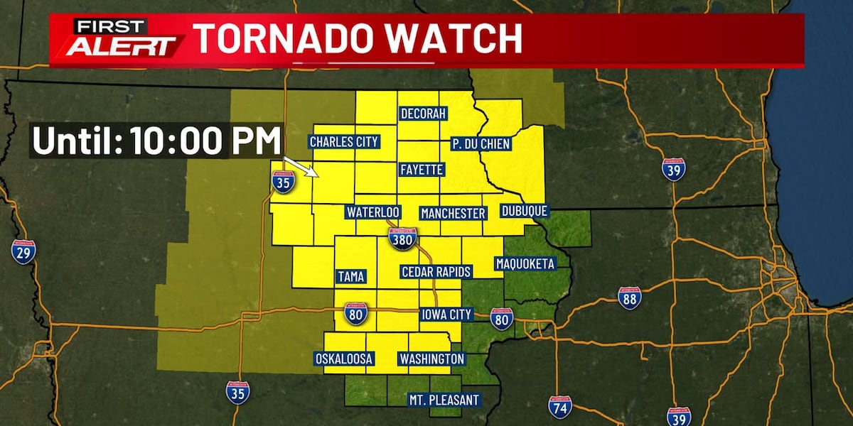
A significant weather alert, a Tornado Watch, has been issued for eastern Iowa, prompting immediate attention and safety preparations across the region. The watch, which signifies that conditions are favorable for tornadoes to develop, is in effect until 10 p.m. tonight, as storms are projected to move into the area. Local news organizations, including KCRG, KCCI, and KGAN, are actively broadcasting and publishing updates, emphasizing the potential danger and advising residents to stay vigilant.
What Happened: The Issuance of a Tornado Watch
The core of the trending topic is the official declaration of a Tornado Watch for a substantial portion of eastern Iowa. This alert is not a warning of an imminent tornado, but rather a declaration by meteorologists that the atmospheric conditions are ripe for tornado formation. These conditions typically include moisture, instability, and wind shear – the ingredients necessary for powerful thunderstorms to rotate and potentially spawn tornadoes. The news coverage highlights the specific timeframe of the watch (until 10 p.m.) and the geographical scope, informing residents of the affected counties.
Why This Matters: Understanding Tornado Watches and Preparedness
The issuance of a Tornado Watch is a critical signal for public safety. It means that residents in the affected areas need to be aware of the developing weather and have a plan in place should a tornado warning be issued later. A Tornado Watch should prompt individuals and families to:
- Review their tornado safety procedures.
- Identify the safest place in their home or workplace (e.g., a basement, storm cellar, or an interior room on the lowest floor, away from windows).
- Secure outdoor items that could become projectiles in high winds.
- Stay informed by monitoring local weather forecasts via reliable sources like NOAA Weather Radio, local TV, or radio broadcasts.
The distinction between a Tornado Watch and a Tornado Warning is crucial. A Tornado Watch means tornadoes are possible, while a Tornado Warning means a tornado has been sighted or indicated by weather radar, and immediate shelter is necessary.
"A Tornado Watch means be prepared. A Tornado Warning means take action immediately." - National Weather Service
Background Context: Tornado Climatology and Severe Weather in Iowa
Iowa is situated within "Tornado Alley," a region of the United States that experiences a high frequency of tornadoes. The state's geographical location, particularly its susceptibility to clashes between warm, moist air from the Gulf of Mexico and cooler, dry air from the north or west, creates ideal conditions for severe thunderstorms and tornadoes, especially during the spring and summer months. Understanding this climatological context helps explain why alerts like this Tornado Watch are not uncommon but always warrant serious attention.
The timing of this particular watch, with storms expected to move in, suggests an active weather pattern is unfolding. Meteorologists will be closely monitoring radar and storm reports to track the movement and intensity of these developing systems. The advanced notice provided by a Tornado Watch is invaluable for emergency management agencies and the public alike, allowing for preparation and potentially saving lives.
What to Expect Next: Monitoring the Storms
As the evening progresses, all eyes will be on the sky and weather radar in eastern Iowa. Residents under the Tornado Watch should remain alert and ready to act if a Tornado Warning is issued. Emergency officials will continue to provide updates, and news outlets will offer continuous coverage of the developing situation. The primary goal is to ensure the safety of all residents by providing timely and accurate information. The intensity and path of the storms will determine whether the watch remains in effect for its full duration or if tornado warnings will be issued for specific areas.
The National Weather Service will be issuing advisories and warnings based on real-time observations. It is imperative for individuals to have multiple ways to receive these warnings, especially during periods of severe weather when power outages can occur. Staying informed and having a safety plan are the most effective ways to mitigate the risks associated with severe thunderstorms and potential tornadoes.
Key Takeaway: The issuance of a Tornado Watch for eastern Iowa signifies favorable conditions for tornado development and necessitates immediate preparedness and vigilance until the alert expires or is upgraded to a warning.